The National Weather Service’s high-end forecast puts as much as 24 inches of snow on the ground by Saturday morning, while the rest of the weekend stays dry and cold. For drivers, the bigger concern is what wet pavement does once temperatures drop after dark.
What The Snowfall Map Shows
NOAA/National Weather Service
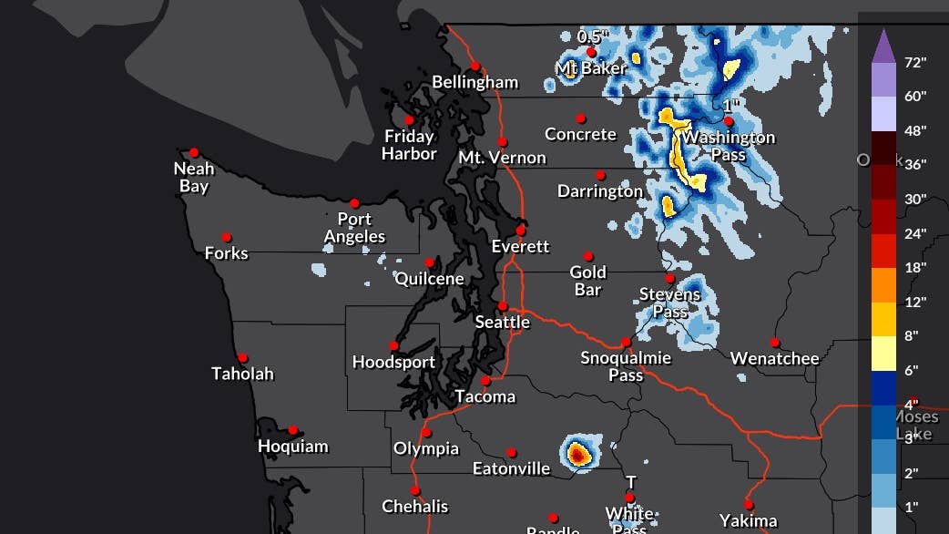
NWS Seattle’s snowfall maps, issued at 7:17 a.m. ET Friday and valid through 8 a.m. ET Monday, put nearly all of the accumulation on Mount Rainier. The official expected forecast shades the center of the mountain in the 12 to 18 inch range, the same figure the office had on Wednesday. Its high-end map, which represents a 10 percent chance of the snowfall total being exceeded, puts the center of the mountain at 24 inches or more.
Elsewhere the totals drop quickly. The North Cascades carry scattered bands of 1 to 4 inches in the expected forecast and up to 8 to 12 inches in the high-end version, with Mount Baker lighter still. The lowlands stay dry.
Highway Passes
The snowfall table from NWS Seattle tells drivers more than the map does. Washington Pass on State Route 20 has an 86 percent chance of at least a tenth of an inch, up from 43 percent in Wednesday’s table, with half an inch expected and an inch in the high-end case. NWS Spokane’s forecast discussion, issued at 4:53 a.m. ET Friday, gives Washington Pass a 40 to 60 percent chance of an inch by Saturday morning, with snow limited to elevations above 5,000 feet from late Friday afternoon through Friday night.
Paradise, on Rainier’s south side, has half an inch expected and up to 2 inches in the high-end forecast. Stevens Pass on U.S. 2 tops out at half an inch with a 27 percent chance of measurable snow, and White Pass on U.S. 12 at a trace. Snoqualmie Pass on Interstate 90 has no snow in the table at all.
Wind And Dust
The cold front behind the snow is moving across the whole Pacific Northwest on Friday, and east of the Cascades it brings wind instead. NWS Spokane has a wind advisory from 2 p.m. ET Friday to midnight ET for the Spokane area, Moses Lake, the Upper Columbia Basin, the Waterville Plateau and the Washington Palouse, along with the Coeur d’Alene area and the Idaho Palouse, with gusts of 40 to 50 mph. Forecasters flag a risk of blowing dust across the Columbia Basin on Friday afternoon, and scattered thunderstorms near the Canadian border could add gusts to 50 mph and small hail.
Conditions then stay dry through Monday. Colder air behind the front brings a chance of frost on Saturday night and Sunday morning in the mountain valleys of eastern Washington and the Idaho Panhandle and in outlying areas around Spokane and the Palouse, the first of the season for many of them.
Before You Drive
The snow that does reach the passes falls mostly overnight on Friday, so the risk on State Route 20 and U.S. 2 is slush that refreezes before sunrise Saturday rather than deep accumulation. East of the mountains, 40 to 50 mph gusts are hardest on trucks, RVs and anything towing, and blowing dust can drop visibility across open stretches of the Columbia Basin with little warning. Sunday morning’s frost will also be an early cold-weather test for tires, since pressures fall by roughly 1 to 2 psi for every 10 degrees, and bridges and shaded corners will ice before the rest of the road. All-wheel drive can help with traction when pulling away on slick pavement, but it does not provide the same benefit when braking.