If you are heading into the Washington Cascades this week, a cold front arriving Thursday brings snow to the high ground. The snowfall map NWS Seattle issued Wednesday morning puts the heaviest amounts on Mount Rainier, where the center of the mountain is shaded in the 12 to 18 inch range through Saturday morning. Most of it falls Thursday night and Friday, and the NWS point forecast for Rainier’s summit warns the snow could be heavy at times.
What The Snowfall Map Shows
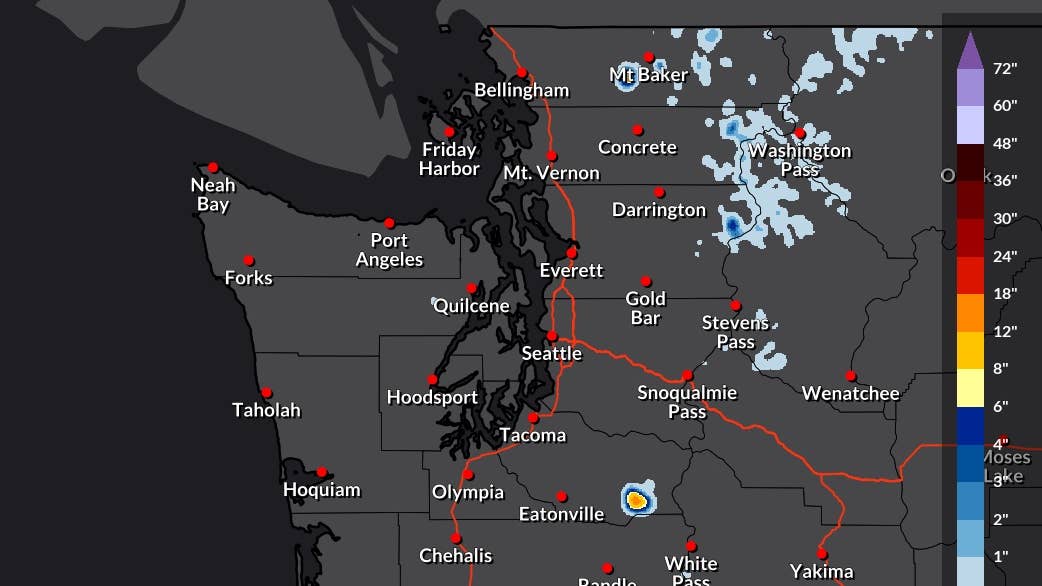
NOAA / National Weather Service
Rainier is the only spot on the map above a foot. Elsewhere the snow is much lighter, with a band of blue along the North Cascades from Mount Baker past Washington Pass and a few patches near Stevens Pass.
Forecasters in Seattle and Spokane have the snow level between 6,000 and 7,000 feet on Friday before it drops to around 5,000 feet overnight, and the NWS Seattle area forecast discussion keeps temperatures cooler than normal into next week.
Highway Passes On The Map
Washington Pass on the North Cascades Highway, State Route 20, has the highest chance of snow among the Cascade passes in NWS Seattle’s snowfall table, at 43 percent for at least a tenth of an inch. The point forecast for Washington Pass has rain on Friday turning to snow showers at night as temperatures fall below freezing. Wet pavement could turn icy by early Saturday, before the sky clears.
Farther south, the same table has half an inch expected at Paradise on Rainier’s south side and a small chance at White Pass on U.S. 12, and no snow at Stevens Pass on U.S. 2 or Snoqualmie Pass on Interstate 90.
Where Else Snow Is Falling This Week
Alaska’s Dalton Highway
Northern Alaska is already seeing snow, including on the Dalton Highway. NWS Fairbanks expects 2 to 4 inches across the Brooks Range, with more above pass level, and its area forecast discussion warns that falling snow and gusty winds could cut visibility. At Atigun Pass, where the Dalton crosses the range, the NWS point forecast has snow through this evening, with a high near 24 and a low around 17 tonight. Lower on the highway, from the Yukon River Bridge through Coldfoot, snow showers stay under an inch, and the discussion has another 1 to 3 inches possible on the North Slope from Sunday night into Monday.
Parks And Richardson Highways
The Parks and Richardson highways, the two main roads north toward the Dalton, also face strong winds. NWS Fairbanks has a High Wind Watch on both from Thursday evening through Saturday afternoon, with gusts around 60 to 70 mph.
Colorado And The Rockies
In Colorado’s San Juan Mountains, NWS forecasts show mostly rain mixed with snow on the high peaks and little accumulation through Thursday. More snow is possible on the higher peaks of the Rockies early next week.
Before You Drive
Early season snow often melts on warm pavement during the day and refreezes after dark, so overnight temperatures on the passes are worth watching. All-wheel drive can help with acceleration, but it does not provide extra braking traction. In Alaska, studded tires have been legal north of the 60th parallel since Sept. 16, and near the Alaska Range, gusts that strong are hardest on RVs, trucks and anything towing.