The National Weather Service snow forecast for northern Alaska puts a band of new snow along the Brooks Range through Friday. Five separate forecast zones carry snow showers between Thursday night and Saturday morning. Only one of them accumulates anything, and that zone happens to contain the only road in the country that crosses the Brooks Range.
Where The Snow Falls
The band stretches across most of northern Alaska. On the Arctic coastal plain north of the mountains there are isolated snow showers overnight and again Friday morning. The heaviest snow falls along the central spine of the Brooks Range. The southern foothills get the same showers, which reach the small settlements along the upper Dalton and melt as they land. Furthest east, almost at the Canadian border, the Romanzof Mountains are the coldest ground in the country this weekend, with lows in the mid teens overnight, Friday highs only in the upper 20s and snow showers continuing through Sunday.
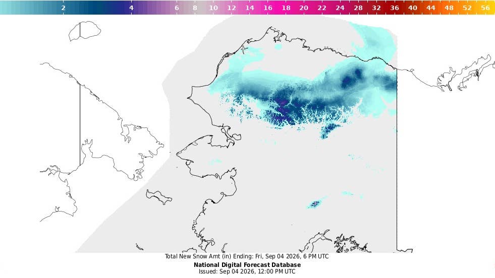
NWS
The Dalton Highway runs through the band for more than 200 miles, and the snow only accumulates on about 90 of those.
What decides that is elevation. The snow level sits at 1,800 feet, and above it the zone forecast from NWS Fairbanks gives up to an inch overnight and less than an inch again through Friday. Below it the same forecast states no accumulation and lows in the mid 30s, so the showers land on ground that is still too warm to hold them.
The Dalton Highway
The Dalton Highway runs 414 miles from Fairbanks to the oil fields at Prudhoe Bay, most of it gravel. Halfway along, it crosses the Continental Divide at Atigun Pass, 4,739 feet up. Atigun is the highest year-round maintained pass in Alaska and the only place a road crosses the Brooks Range at all, so a driver heading north has no way around it.
The pass is nearly 3,000 feet above the snow level, putting it well inside the area where snow can accumulate. The descent off the north side runs at grades reaching 12 percent.
Overnight Temperatures
The snow goes down wet. Lows are in the lower 30s overnight Thursday and the lower to mid 30s again Friday night, close enough to freezing on two consecutive nights for daytime meltwater to firm up after dark. Winds are light throughout, variable and under 15 mph, so blowing snow and reduced visibility are not part of this one.
Earlier Snow This Season
This is the fifth time snow has been forecast on this stretch since late July. NWS Fairbanks issued winter weather advisories in the last week of July and again in late August, plus special weather statements on 25 August and 1 September, the last of those calling for 3 to 6 inches above 2,000 feet. Snow on the Brooks Range in early September is not a freak occurrence, and northern Alaska is routinely the first part of the country to record measurable snowfall each year.
Tires And Traction
Studded tires cannot legally be fitted north of the 60th parallel until 16 September. Alaska statute runs the seasonal prohibition on paved highway from 1 May through 15 September inclusive, which leaves eleven more days on the clock. Chains carry no date at all. State regulation allows them whenever conditions warrant, so this weekend they are the only device that is both legal and matched to what the forecast describes.
Everything else on the road is on all-season or winter tires, and only winter compound stays flexible once temperatures reach the low 30s. All-wheel drive is not a substitute. It helps a vehicle accelerate and does nothing for braking or cornering, which is what fails on a refrozen surface. Pressure matters too. Cold costs roughly 1 to 2 psi for every 10 degrees the temperature falls, so a set inflated in July is underinflated now, and a gauge is the only way to tell.