If you are driving I-70 this weekend, today is not the day to start. The National Weather Service has a Winter Weather Advisory active right now for Colorado’s mountain passes and a Freeze Warning covering the entire Front Range urban corridor and northeast plains tonight through Saturday morning. The storm clears Saturday, but the damage to roads and vegetation will already be done.
What makes this one worth paying attention to is not the snow totals in the mountains. It is the freeze behind it. Denver was in the upper 70s yesterday. Tonight, lows across the Front Range will fall to 18 to 24 degrees. That is more than 50 degrees in under 36 hours, and anyone who has already turned on their sprinkler system is about to find out the hard way.
The Storm
The cold front that hit Wyoming this week crossed the Colorado border overnight. NWS Boulder confirmed it in their Area Forecast Discussion issued at 5:27 AM today: a spring storm moving in with snow showers and a much colder air mass, with a hard freeze expected across the plains Friday night.
Snow is already developing in the mountains this morning and spreading to lower elevations through the day. Denver’s forecast high today is in the low 40s with an 80 percent chance of snow showers. The city has not seen measurable snow since March 15. The snow at lower elevations will be light and mostly wet, but the main concern is what happens to wet roads when temperatures crash into the teens tonight.
Saturday clears along the Front Range. Denver gets back to the upper 50s under sunshine, and the low 70s by Sunday. The AFD calls for a warming trend with mostly dry conditions through Tuesday, though the mountains may see low-end rain or snow chances Monday and Tuesday at higher elevations.
NWS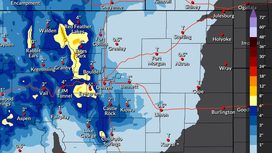
The Highways
The Eisenhower-Johnson Memorial Tunnel on I-70 at 11,158 feet is taking the worst of it today: 2 to 4 inches of snow with heavy bursts and gusts to 34 mph through 5 PM. The AFD notes snow accumulations of 2 to 9 inches above 9,000 feet and 2 to 6 inches in the foothills, with hazardous driving conditions possible along I-70 and mountain passes late this morning through early Friday afternoon. Berthoud Pass on US-40, the two-lane alternative when I-70 closes, is in the same advisory zone. Conditions are set to improve on Saturday as warmer, drier air moves in, but today’s travel window through the mountains is narrow. CDOT’s Traction Law is in effect through May 31 between Dotsero and Morrison.
The Front Range along I-25 will not see much snow, but do not let that fool you. The Freeze Warning means every bridge deck and overpass from Fort Collins through Denver to Colorado Springs will ice over tonight. Lows of 18 to 24 degrees on wet pavement is black ice, not snow, and that is harder to see and harder to recover from. Colorado Springs faces a second round: NWS Pueblo has issued a Freeze Watch for Saturday night into Sunday morning as well.
When To Drive
Today is not a mountain day. The advisory is active through 5 PM at the higher passes, snow is falling, and roads above 10,000 feet are getting slick. If you absolutely must cross I-70 today, go now, early morning, before conditions build through the afternoon.
Tonight is the worst window on the Front Range as a result of ice. The Freeze Warning activates at 8 PM as everything that melts during the day refreezes. It is expected that every bridge on I-25 and I-76 will have ice on it by midnight.
Saturday the Front Range recovers. Denver is sunny and near 60. Mountain passes should be clearing, though residual ice is possible on shaded sections.
Sunday and Monday warm further, with highs reaching the 70s in Denver. The AFD expects mostly dry conditions through Tuesday.
US NWS![]()
The Freeze
This is the part that will affect the most people, with Denver in the upper 70s one day, and hard freeze the next. The NWS Freeze Warning issued at 1:07 AM today is specific about the damage: above-ground irrigation lines will likely fail if they are not drained or protected, and a hard freeze will kill sensitive vegetation and damage fruit trees. This winter was warm enough that many homeowners turned on their systems weeks ago. February brought spring flowers out across the metro area.
Colorado’s statewide snowpack was sitting at 17 percent of the median peak as of April 13, the worst in four decades. The mountains will take whatever moisture this system delivers. The Front Range just gets the cold.
Before You Drive
Your tires matter more than your drivetrain this weekend. Colorado law requires 3/16-inch tread depth. Cold drops tire pressure 1 to 2 PSI per 10-degree change, and most people do not check until they are already sliding. AWD helps you go but does not help you stop on ice, which is what the Front Range will have after tonight.
If you are crossing the passes today, throw chains or traction devices in the vehicle along with a blanket, water, phone charger, and a flashlight.
Road Conditions
Make sure to visit COtrip.org for real-time I-70 conditions, live cameras, and active traction law status. For updated mountain weather and winter forecasts, use the Colorado 511 mobile app, dial 511 from any phone in Colorado, or go to NWS Boulder.